

[ad_1]
Source: Routescène
What do Green Bay Packers and Forest Sweeping Drones have in common? Cheese heads.
While Packer fans proudly identify with the dairy-infused moniker, a University of Wisconsin-Madison research project has adapted the name of a groundbreaking UAV project to improve weather forecasting by understanding how the vegetation and forests influence the atmosphere.
CHEESEHEAD (Chequamegon Heterogeneous Ecosystem Energy-balance Study Enabled by a High-density Extensive Array of Detectors) aims to study the interactions and feedbacks between the Earth’s surface and the atmosphere and how these results can be used to optimize climate models. The result? Better policy development to reduce carbon emissions.
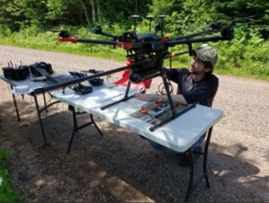
Researchers are using Routescene’s LiDAR UAV system to collect high-density 3D point cloud data from important tree species in the Chequamegon-Nicolet National Forest. Routescene’s drone-mounted LiDAR system can capture the entire tree structure, from canopy to vegetation at ground level.
Cover the canopy
The drone-mounted LiDAR can quickly and efficiently study and represent the type, shape and composition of the entire forest canopy with studies deployed around 11 100-foot flow towers in areas ranging from 61 to 247 acres. . Six types of forests have been identified, including aspen, pine, poplar, larch, cedar and hardwood.
“The large 20 to 30 m high canopy created difficult flight conditions,†said researcher Christian Andresen. “It was difficult to keep a visual line of sight, so we decided to do smaller flights of 500 x 500m to keep the sight of the drone. “
“The Routescene system worked perfectly, we achieved everything we had planned. During the 3 days, our two-person crew covered a total of 4.2 km². We were particularly impressed with the density of the overlapping flight lines and the mapping of the forest structure.
The Routescene LiDAR system includes a 32-laser LiDAR sensor offering a scanning speed of up to 1.4 million points per second. The density of the point clouds averaged 600 points per square meter with a vertical accuracy of 2 to 5 cm.
Routescene diversifies
For Routescene, tree research is becoming an increasing part of the business model of the European drone supplier.
In June, the company partnered with the University of Toledo to assess a forest fire site in the Spanish province of Albacete to better understand the severity and distribution of the fire.
“The project demonstrated the potential to distinguish plant structures in detail after the fire using LiDAR data from UAVs. When crossed with satellite fire severity measurements, the high-resolution results allow researchers to estimate the impact of fires on single trees and not just entire forest areas, using measurements that are ecologically significant down to the level of an individual tree.
Currently, California-based Skyfront is collaborating with Routescene to explore the impact of increasing flight endurance, using Skyfront’s Perimeter 8 gasoline-electric hybrid multicopter.
Jason is a longtime DroneLife contributor with a keen interest in all things tech. It focuses on anti-drone technologies and the public security sector; police, fire and search and rescue.
Beginning his journalistic career in 1996, Jason has since written and edited thousands of captivating news articles, blog posts, press releases and online content.
Email Jason
TWITTER:@JasonPReagan
Subscribe to DroneLife here.
[ad_2]


